
Missing Middle Models: A Milestone for the Mountain West
The Northern South Park (NSP) Area I Master Plan in Jackson, Wyoming, marks a significant advance in “missing middle” housing principles for a rapidly growing, rural-suburban community. As the fourth entry in evolveEA’s “Missing Middle Models” blog series, this post focuses on the Northern South Park Area I Master Plan to distill lessons learned from infill revitalization in legacy cities, the rise of modular construction, and planning for equity. Here, we explore how a bold, landowner-led initiative set the stage for a mixed-income neighborhood with a diversity of building typologies and scales. We will also focus on how landscape conservation and natural ecosystems can drive design in one of the country’s most economically polarized housing markets.
Northern South Park – evolveEA
Planning Through the Missing Middle Lens
Jackson Hole faces a deepening housing crisis exacerbated by land scarcity, a booming tourism economy, and a growing service-sector workforce. Against this backdrop, the Gill family has voluntarily offered over 100 acres of their ranchland for residential development, laying the foundation for the largest housing project in Teton County history. The NSP plan, approved in May 2025 by the Teton County Board of Commissioners, mandates that 70% of all homes be deed-restricted for workforce or affordable housing. The plan resonates with a decades-long call for action. In 1977, conservationist Mardy Murie warned that Jackson had surpassed its critical hour for equitable growth. Today, her sentiments echo through NSP’s commitment to providing for the people who build, service, and sustain this iconic mountain town.
Housing Typology & Density
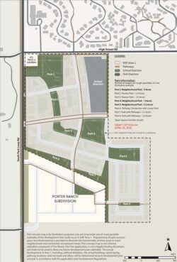
The NSP Area I Master Plan caps the number of residential units at 600, blending a spectrum of housing types across the 74.13 acre site. The proposed mix includes approximately 435 multi-family units, 95 duplexes and townhouses, and 70 single-family homes. These arrangements reflect classic Missing Middle typologies: scaled housing forms that bridge the gap between detached single-family homes and large apartment complexes.
Each block, ranging from 2.5 to 5 acres, is designated entirely as either deed-restricted or market-rate, supporting development tailored to specific needs. Affordable housing is located closer to town amenities and transit in the northern and central areas, while market-rate homes are generally planned for the southern edge.
Equity in Practice
NSP is more than a housing development; it is a model for how land-use planning can advance equity. The Gill family will donate land for affordable housing to nonprofit developers such as Habitat for Humanity and the Jackson Hole Community Housing Trust. These partnerships ensure that the majority of new homes will be accessible to locals, rather than second-home buyers.
This approach echoes principles discussed in our “Planning for Equity” post—highlighting the value of embedded affordability, income-targeted housing policies, and sustained community partnerships.
Smart Phasing & Flexibility
The NSP Area I Master Plan will unfold in phases, guided by a framework that allows for adaptation over time. Infrastructure development, traffic mitigation, and park and school exaction land delivery are all embedded in phasing agreements, ensuring that the neighborhood evolves in balance with its surroundings. Flexibility is key: individual block plans will be approved incrementally, allowing public input and policy alignment to shape outcomes.
Site Design: Neighborhood Fabric That Works
At the start of the design process, the evolveEA team identified and analyzed several potential site organizing features. “We examined the patterns of existing water channels and ditches on site, noting their lines of cottonwood trees and the importance of water. We also developed figure–ground diagrams of neighborhoods throughout town to understand block scales and street patterns, and we visited examples of affordable housing in the community to learn from their approaches.”
At the master site planning phase, the clearest throughline came from the landscape ecosystem diagrams we created to illustrate the relationships between site elements at different scales. At the micro scale, we focused on water and vegetation patterns within the site. At the meso scale, we analyzed groundwater dynamics, habitat pockets, and the ways human activity and wildlife intersect in the South Park area, including the role of the Snake River as a vital corridor for wildlife and elk migration. At the macro scale, we considered the site’s position within its broader geological context, framed by the Grand Tetons, Snow King, and other peaks, and how to maximize the foreground and background experience for future residents.
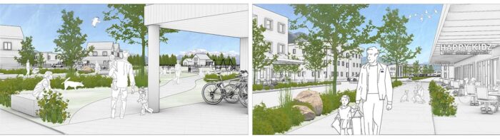
The layering of these analyses created a defining feature of the NSP plan. Rather than traditional square parks, the site includes linear open spaces allowing for the integration of open space throughout the site, with opportunities for both passive and active recreation, and for multi-modal access throughout. Every home will be within a quarter mile of a park or open space.
Open space and development are two sides of the same coin in the future Northern South Park neighborhood, with the call to develop a high-quality neighborhood that could include up to 600 residential units. The neighborhood plan calls for the highest density units in the northern edge of the site, along High School Road. The design team shifted the center one block south into the site to create a neighborhood hub that is prioritized for local neighborhood residents while also serving as a connection with the larger community. The choice to locate it at the center of the future NSP-3 zoning blocks, allows for a more pedestrian-oriented public realm with a clear center and potential amenities like a coffee shop and proximity to Smith’s Food and Drug, the future park space and school, and a walkable scale that aligns with missing middle principles. Deed-restricted housing blocks are located near these services, reinforcing equitable access.
Key transportation and mobility improvements—including traffic calming measures, local roads with pathways and sidewalks, connections to the greater community pathway system, and START bus stops—reflect the plan’s commitment to sustainable mobility. The proposed E-W connector, which is identified in the West Jackson Transportation Study, would help connect the two areas of the Northern South Park neighborhood (Area I is the site of this master site plan) with the larger roadway network, while also creating greater redundancy in the road network. The design encourages active transportation while accommodating future connections across the broader South Park area.
Northern South Park offers a replicable template for other growing communities, especially those in mountain and resort towns grappling with affordability, sprawl, and social division. By aligning private initiative with public planning goals, the NSP model shows how bold commitments from landowners like the Gill family, local governments, and nonprofit partners can reimagine growth. From legacy cities to rural regions, the Missing Middle approach continues to evolve. NSP reveals that equitable, mixed-income neighborhoods are not only possible: they’re necessary.
Northern South Park is more than a master plan—it’s a signal of what’s possible when vision, policy, and community values converge. As evolveEA continues to document and support innovative Missing Middle models across the country, NSP stands as a case study in inclusive growth rooted in place, purpose, and partnership.
Stay tuned as the project continues to develop and as we explore future themes like resilience planning and climate adaptation in communities embracing the Missing Middle.