
Planning Scorecards that Go Beyond
Whether you’re engaging in community planning for a region, or sustainability goal setting for a building, it’s important to see clear, specific, measurable goals. Achievable goals should have indicators—baseline and targets. At evolveEA, we develop scorecards for green space plans and other types of urban planning to track these indicators. A key reason we value scorecards is the need for more granular data to inform decision-making than can be achieved with existing tools. Communities making investments in their infrastructure and shared assets like parks, trails and recreation facilities want to make sure that these have a real impact towards achieving their goals. We also know that when scoring can be reevaluated later, better decisions can be made and goals are more likely to be met.
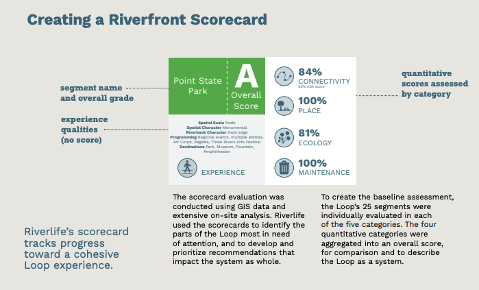
A custom scorecard developed by evolveEA for the Completing the Loop riverfront master plan
What really makes scorecards work for our clients is that they are customized based on their unique community goals. We work with community leaders and stakeholders to set specific and achievable goals based on data. We help determine the best metrics to track progress and measure the goals, and sometimes if the tracking system doesn’t exist, we create it.
For the Our Parks Lancaster plan, we worked with a steering committee including representatives from Lancaster city, county, and recreational organizations to identify the components of a high-quality park system. Residents also contributed through a public engagement process, and we indexed a long list of ideas, such as “there should be activities and amenities for people of all ages and from all backgrounds, providing language and cultural access” and “focus on nature and ecology”. We also used national studies and other evaluation systems, such as the Trust for Public Land’s Park Score, the National Recreation and Parks Association benchmarks, Change Lab Solutions Complete Parks Indicators: A systems approach to assessing parks, ULI’s Five Characteristics of High Quality Parks, and the Pennsylvania Statewide Comprehensive Outdoor Recreation Plan. Our scorecard for Landcaster distills all of this information into a system for evaluating the city’s individual parks using onsite surveys and GIS.
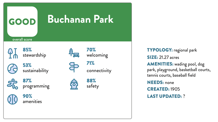
The Lancaster Parks scorecard evaluates:
- Stewardship – is the park clean and well-maintained?
- Sustainability – does the park contribute to stormwater management, growing the urban forest, and reducing the urban heat island effect?
- Programming and activities – How many types of uses and programming are available in the parks, and do they provide flexibility in programming?
- Amenities – Are there a variety of amenities available and what is their condition?
- Welcoming and relevant – Does the park appear inviting and welcoming, is it comfortable to spend time in, are entrances clear and well-signed?
- Connectivity, Access & Accessibility – is it safe to walk or bike to the park? Can it be accessed by public transit, is it generally accessible?
- Safety – is the park visible from and well-integrated into the neighborhood, does it feel safe, are adjacent land uses compatible with a park?
We also have three system-wide criteria evaluating how much Lancaster’s parks are knowable and transparent, their size and distribution, and the level of investment, all based on benchmarking, GIS data, and community surveys. Having a documented scorecard helps keep our process transparent and it helps organizations, municipalities and public agencies stay accountable to the public and earn their trust. Furthermore, scoring can reveal or validate inequities in our urban systems and establish a mandate to change the status quo. For Lancaster, our scoring and benchmarking analysis identified that the southeast quadrant of the city was underserved by the local parks system, so our recommendations will prioritize action in those neighborhoods.
Similarly, the scorecards we created for Riverlife’s Completing the Loop riverfront master plan highlighted parts of the trail system where some neighborhoods that are a short distance from the rivers are currently disconnected from them by infrastructure like railways and highways. The plan identified places where Riverlife and their partners could not only carve out pedestrian and bike access to the trail system, but also create rich new experiences for all trail users in Pittsburgh by adding places for recreation and enabling new ways to navigate the city. One of the first new projects recommended in Completing the Loop is connecting the West End Bridge to neighborhoods in Pittsburgh’s West End and across the river around the Manchester-Chateau area.
Stakeholders are coming together to plan a series of design interventions for the West End Bridge that will highlight iconic views of Downtown Pittsburgh’s riverfront and create a pleasurable experience for residents who want to cross the river by walking, biking, or even kayaking. The scorecards provide stakeholders with a common language and a clear set of priorities, and are also useful in helping to secure funding. After all, knowing the score is a critical step toward winning!